The Tibetan Plateau is the largest orogenic belt on the Earth with high topography and thickened crust, which extends over 2,000km from the Himalayas to central Asia. It is generally believed that the growth of the Tibetan Plateau is the consequence of the continental collision between the Indian and Eurasia plates since the Cenozoic. However, how the Tibetan Plateau uplifted to its present high topography is a subject of debate.
Assistant Professor Zhen Guo’s team from the Department of Ocean Science and Engineering at the Southern University of Science and Technology (SUSTech) recently used a seismic approach that could simultaneously inverse the shear wave velocity and radial anisotropy to construct a high-resolution 3D radial anisotropy model for the northeastern Tibetan Plateau and its surrounding areas. Their results shed light on the mechanism of the plateau expansion.
Their research results, entitled “Imaging the northeastern crustal boundary of the Tibetan Plateau with radial anisotropy,” were published in the Nature Index journal Geophysical Research Letter.
The results from Prof. Guo’s team clearly shows different crustal radial anisotropy pattern between the Songpan-Ganzi Terrane and the Qilian Orogen. The Songpan-Ganzi Terrane is characterized by the positive crustal radial anisotropy, indicating the presence of the crustal channel flow. Meanwhile, the Qilian orogen is characterized by negative radial anisotropy, which could be caused by folding and thrusting due to crustal shortening.
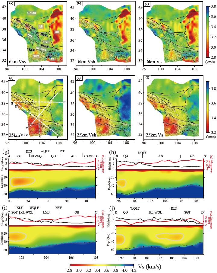
Figure 1. Horizontal slices and vertical section of the crustal Vs. structure
Such difference in crustal radial anisotropy further indicates different stages of mountain-building processes in the Tibetan Plateau. The crustal shortening may have occurred at an early stage in the evolution of the plateau, as observed in the Qilian orogen. However, the crustal channel flow beneath the SGT is at a later stage, likely due to the radioactive heating accumulated during crustal thickening.
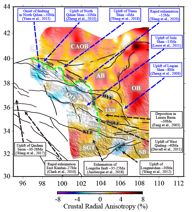
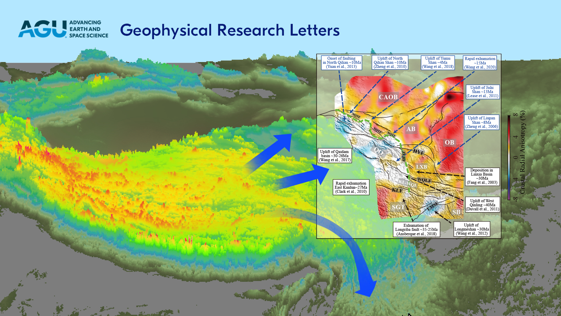
Figure 2. Radial anisotropy in the crust and the timing of the initiation of the major deformation/uplift
Furthermore, the crustal radial anisotropy delineates the northeastern crustal frontier of the expanding Tibetan Plateau: it is situated roughly along the NQFT from 97ºE to 103.5ºE and then turns north-south at 103.5ºE, passing the Zhuanglanghe Fault and terminating at the eastern Kunlun Fault at 34ºN. Their results infer the progressive northeastern expansion of the Tibetan Plateau and clearly show the crustal frontier of the expanding Tibetan Plateau.
Shilin Li, Research Asst. Prof. at SUSTech, is the first author of this paper. Asst. Prof. Zhen Guo and Prof. Yongshun John Chen from SUSTech are the corresponding authors. The co-authors include Research Asst. Prof. Yong Yu and Dr. Xiaoyang Wu from SUSTech. The Department of Ocean Science and Engineering at SUSTech is the first affiliation of this paper.
This work was supported by the National Natural Science Foundation of China (NSFC).
Paper link: https://agupubs.onlinelibrary.wiley.com/doi/10.1029/2022GL100672
To read all stories about SUSTech science, subscribe to the monthly SUSTech Newsletter.
Proofread By
Photo By


