Satellite altimetry has been widely used for inland water monitoring and modeling in the present decade, and up to now, it is the only way to survey inland water elevation at a global scale. However, due to its ocean-oriented nature, it faces many challenges over inland waters.
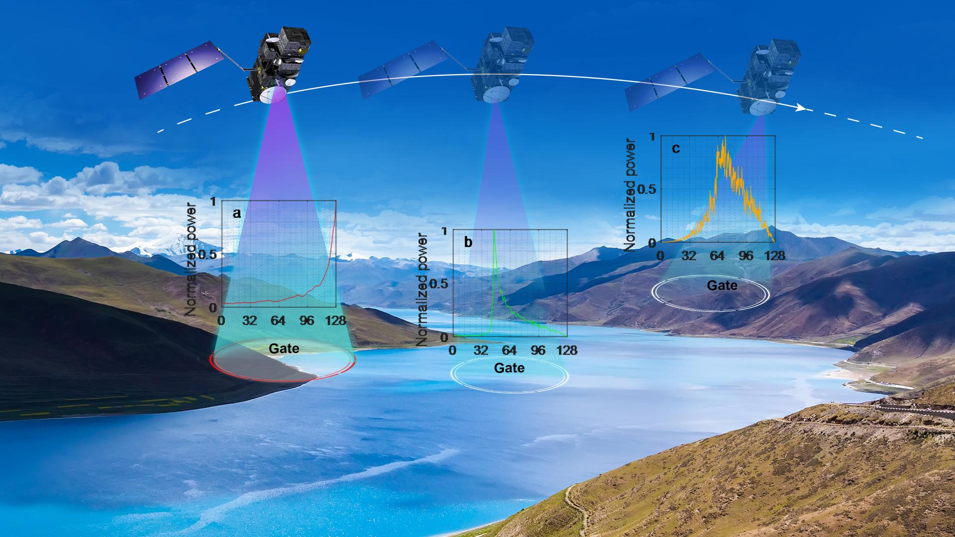
Compared to the open ocean surface, which is relatively smooth and predictable, the topographic surface of land is rough and less predictable. Therefore, over land, it is difficult to correctly position the recording window (the so-called range window) for the onboard tracking and control systems (Figure 1). The narrow range window (usually 30–60 m) may cause data loss or degraded measurements in coastal areas and rugged landscapes. This is sometimes the case over lakes, reservoirs, and rivers that are usually located in valleys.
How has satellite altimetry performance over inland mountainous lakes progressed in the past three decades?
Assistant Professor Liguang Jiang’s research group from the School of Environmental Science and Engineering (ESE) at the Southern University of Science and Technology (SUSTech) has exclusively investigated the performance (both Level 1 and Level 2 data) of different satellite missions over mountainous lakes and published their findings in two journals.
Their work has devoted an in-depth inter-comparison of multiple radar altimeters over mountainous lakes, and with this, aims to assess the progress of inland water altimetry, especially in terms of data acquisition and quality. It intends to provide valuable information for the hydrology community as well as future altimetry missions, especially for inland altimetry improvements.
Their first paper, entitled “Improvements in mountain lake monitoring from satellite altimetry over the past 30 years – lessons learned from Tibetan lakes”, has been published in Remote Sensing of Environment, a prestigious journal serving the Earth observation community with the publication of results on the theory, science, applications, and technology of studies contributing to advance the science of remote sensing.
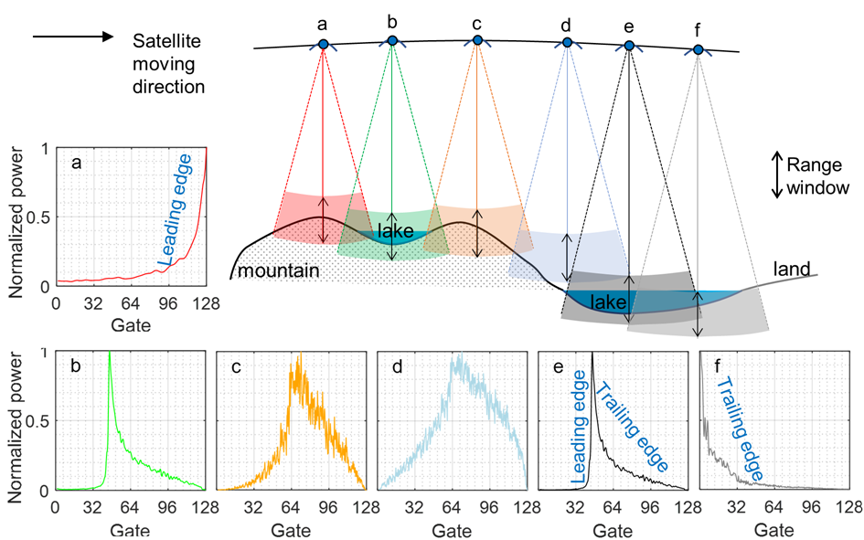
Figure 1. Illustration of scenarios of range window position and corresponding waveform acquired. Note the range window is positioned in time and, therefore, cannot be below the earth’s surface. Here it is simply used for illustration. In cases (a) and (f), the range window is set too early and too later in time, respectively, to capture the full echo reflected by the lake’s surface. In (d), the range window is set way too high or too early in time to record any signal from the lake.
Prof. Jiang’s group also investigated the value of the near real-time satellite product for detecting extreme hydrological events, such as floods. Usually, researchers only use non-time critical product (about one month delay after). But, if time is a major concern, near real-time product would be of great value. Therefore, they assessed the quality of the near real-time product of the Copernicus Sentinel-3 altimetry at a global scale and demonstrated the great value of the near real-time product of flood detection over the Amazon, Congo, and Brahmaputra rivers.
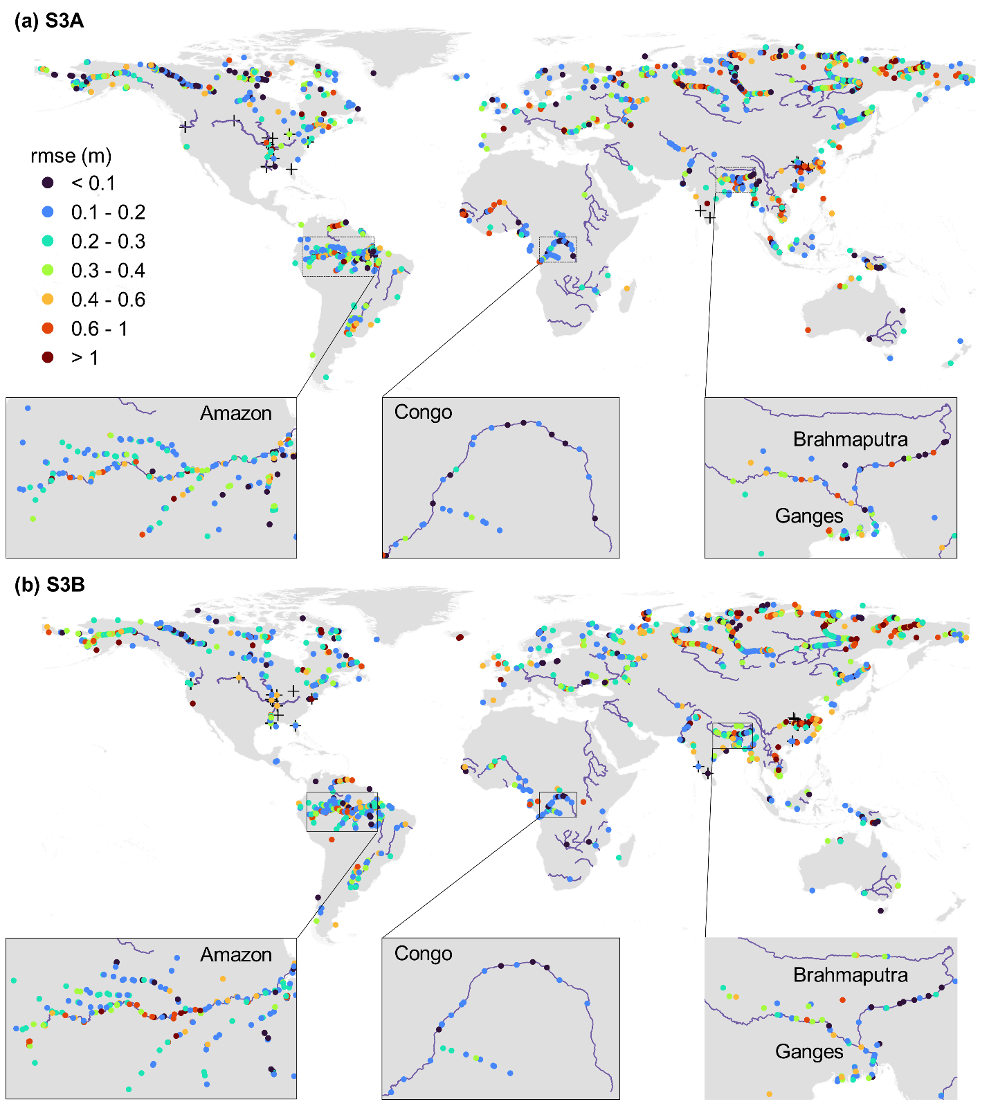
Figure 2. Overview of the virtual stations (VS) evaluated and the RMSE of river WSE time series between NRT and NTC products for (a) Sentinel-3A and (b) Sentinel-3B. Crosses indicate the locations of in-situ gauging stations. Insets show the zoom-in view of evaluation over three large rivers.
Their second paper, which presents this work, has been published in Environmental Research Letters under the title of “Near real-time altimetry for river monitoring—a global assessment of Sentinel-3”.
Asst. Prof. Liguang Jiang from the School of ESE at SUSTech is the first and corresponding author of these papers.
This work was supported by the Start-Up Fund of SUSTech, CRSRI Open Research Program, and the Danida Fellowship Center.
Paper links:
Remote Sensing of Environment: https://doi.org/10.1016/j.rse.2023.113702
Environmental Research Letters: https://doi.org/10.1088/1748-9326/acdd16
To read all stories about SUSTech science, subscribe to the monthly SUSTech Newsletter.
Proofread ByAdrian Cremin, Yingying XIA
Photo By