With the intensification of global climate change, extreme droughts have become more frequent in recent years. Notable events include the 2012 drought in the southwestern United States, the 2019 drought in Yunnan, China, and recent droughts in Henan and Shandong provinces. These events have caused significant impacts on agriculture, ecosystems, and socio-economic conditions.
Droughts are generally categorized into four types: meteorological, hydrological, agricultural, and socio-economic. Meteorological drought, characterized by insufficient precipitation over a specific period, is the initial drought stage. If not alleviated, it can lead to reductions in soil moisture, runoff, lake and reservoir levels, and groundwater, resulting in agricultural and hydrological droughts.
Traditional drought characterization methods often rely on single indicators such as the Standardized Precipitation Index (SPI) for meteorological drought and the Standardized Runoff Index (SRI) for hydrological drought. However, the multi-layered nature and interdependent progression of droughts—where precipitation deficits cascade through soil moisture, runoff, and groundwater—necessitate a more comprehensive approach.
The research group led by Associate Professor Kejie Chen from the Department of Earth and Space Sciences at the Southern University of Science and Technology (SUSTech) has published a study that introduces a novel integrated drought monitoring method that utilizes both Global Navigation Satellite System (GNSS) and precipitation data to consider both meteorological and hydrological indicators simultaneously.
Their paper, entitled “A novel GNSS and precipitation-based integrated drought characterization framework incorporating both meteorological and hydrological indicators”, has been published in Remote Sensing of Environment, a leading journal in the field of remote sensing.
Multi-variable and multi-indicator analyses are required to overcome the limitations of single indicators. For instance, the United States Drought Monitor (USDM) integrates multiple observational sources, including temperature, precipitation, snow, soil moisture, runoff, and crop conditions, to provide a comprehensive drought characterization. Inspired by the USDM approach, this study leverages the capability of GNSS stations to provide atmospheric water vapor content and terrestrial water storage changes independently and simultaneously.
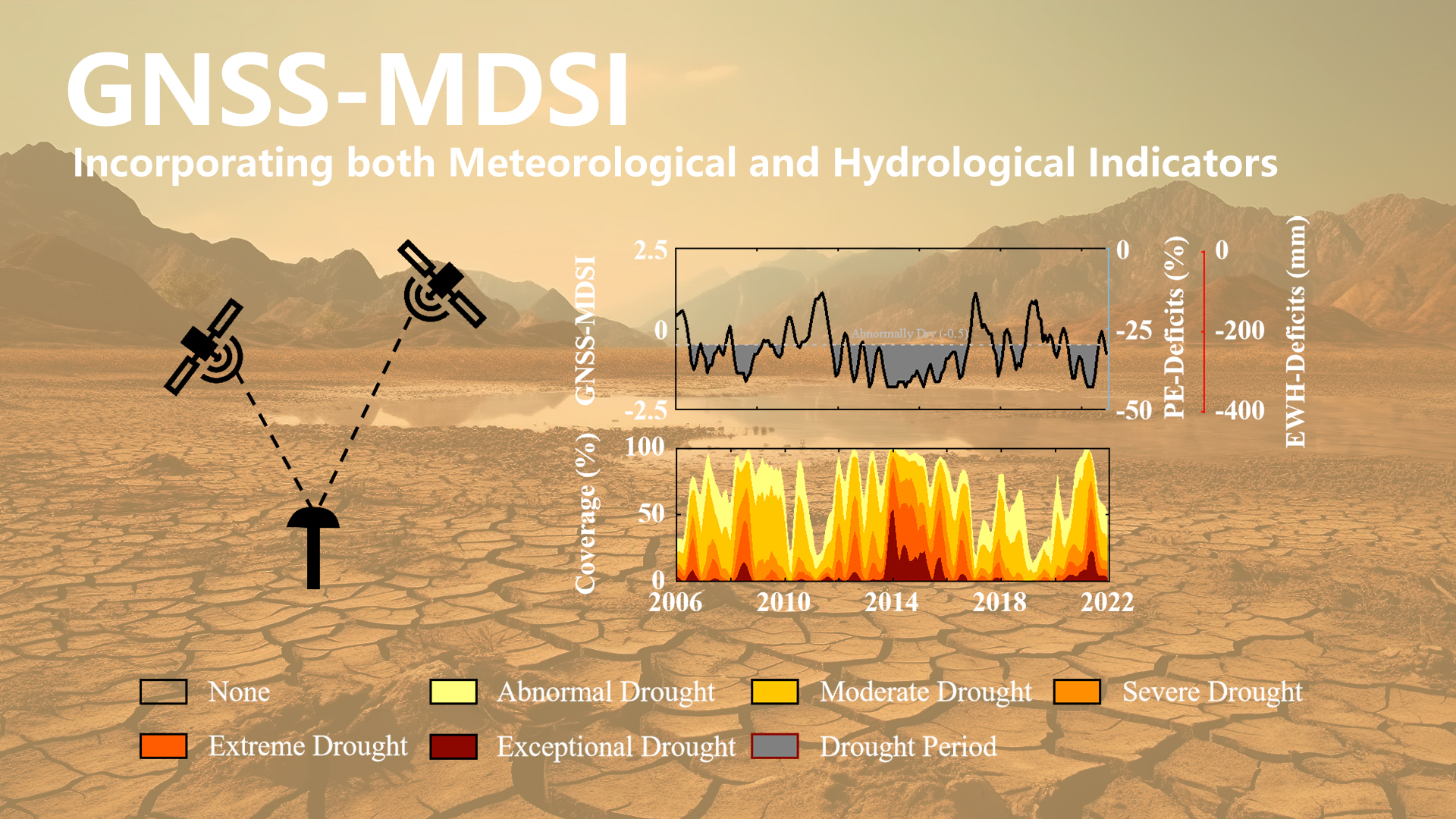
The framework integrates three datasets: GNSS-derived Precipitable Water Vapor (PWV), Vertical Crustal Deformation (VCD), and precipitation data. Specifically, precipitation efficiency (PE) is calculated using PWV and precipitation data to serve as a meteorological drought indicator. Concurrently, vertical crustal deformation is used to derive Equivalent Water Height (EWH) as a hydrological drought indicator. The Gringorten plotting position formula is then employed to derive the empirical joint probability of PE and terrestrial water storage changes, resulting in the GNSS-based Multivariate Drought Severity Index (GNSS-MDSI) for integrated drought characterization (Figure 1).
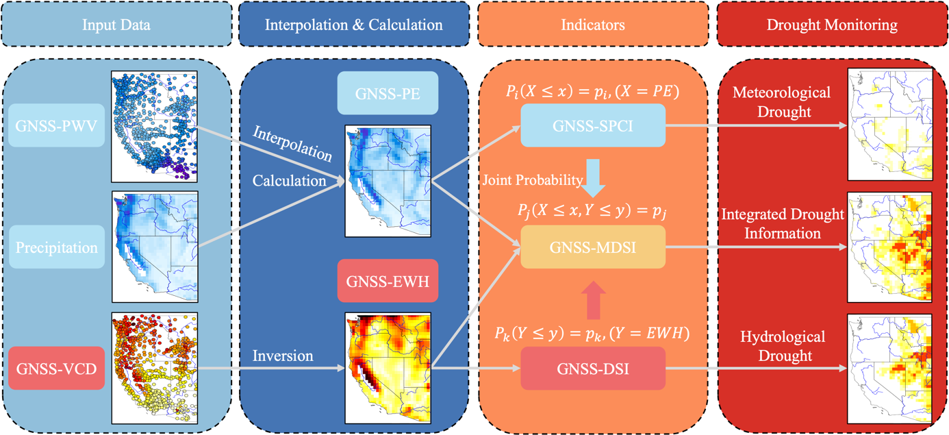
Figure 1. Schematic diagram of the GNSS and precipitation-based integrated drought characterization framework. This illustration emphasizes that the framework relies exclusively on GNSS-derived precipitable water, vertical crustal deformation, and precipitation data without the need for additional external data sources.
The study examined drought events in the western United States from January 2006 to December 2021, comparing the GNSS-MDSI with the USDM (Figure 2). Results indicated that the GNSS-MDSI not only monitored rapidly evolving meteorological droughts but also reflected gradually developing hydrological droughts. When both types of drought occurred simultaneously, the GNSS-MDSI showed higher severity levels. More importantly, the drought characteristics captured by the GNSS-MDSI were overall consistent with those identified by the USDM.
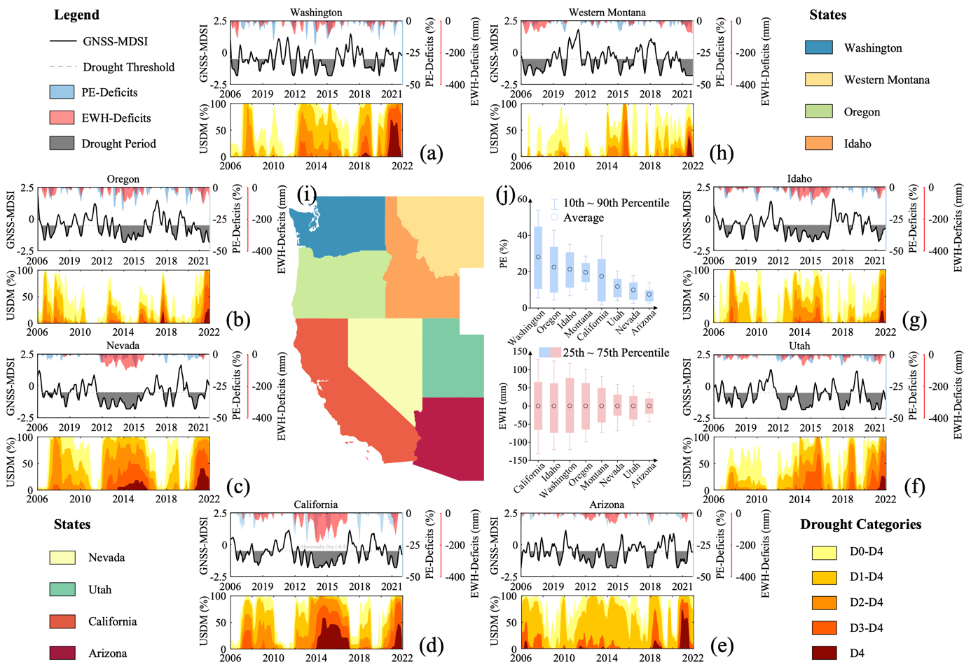
Figure 2. Comparison of GNSS-MDSI and USDM in eight states of western U.S. (h). Subfigure (i) depicts the geographical locations of these states, and subfigure (j) presents boxplots illustrating changes in precipitation efficiency and terrestrial water storage in these states.
This study also analyzed drought events in Yunnan, China, from January 2011 to May 2021, and compared the results with the Composite Index (CI) provided by the China Meteorological Administration’s National Climate Center (Figure 3). The results indicate that a six-month-long meteorological drought began in April 2019.
Two months after the onset, exacerbated by high temperatures, this meteorological drought triggered a severe hydrological drought. Although precipitation increased after 2020, partially alleviating the meteorological drought, the hydrological system did not fully recover. In this context, the GNSS-MDSI accurately captured the onset, duration, and evolution of this drought event. In contrast, the CI, which is based on the 30-day and 90-day Standardized Precipitation Index (SPI) and the 30-day Relative Humidity Index, did not account for hydrological variables and, therefore, failed to effectively capture changes in the hydrological system.
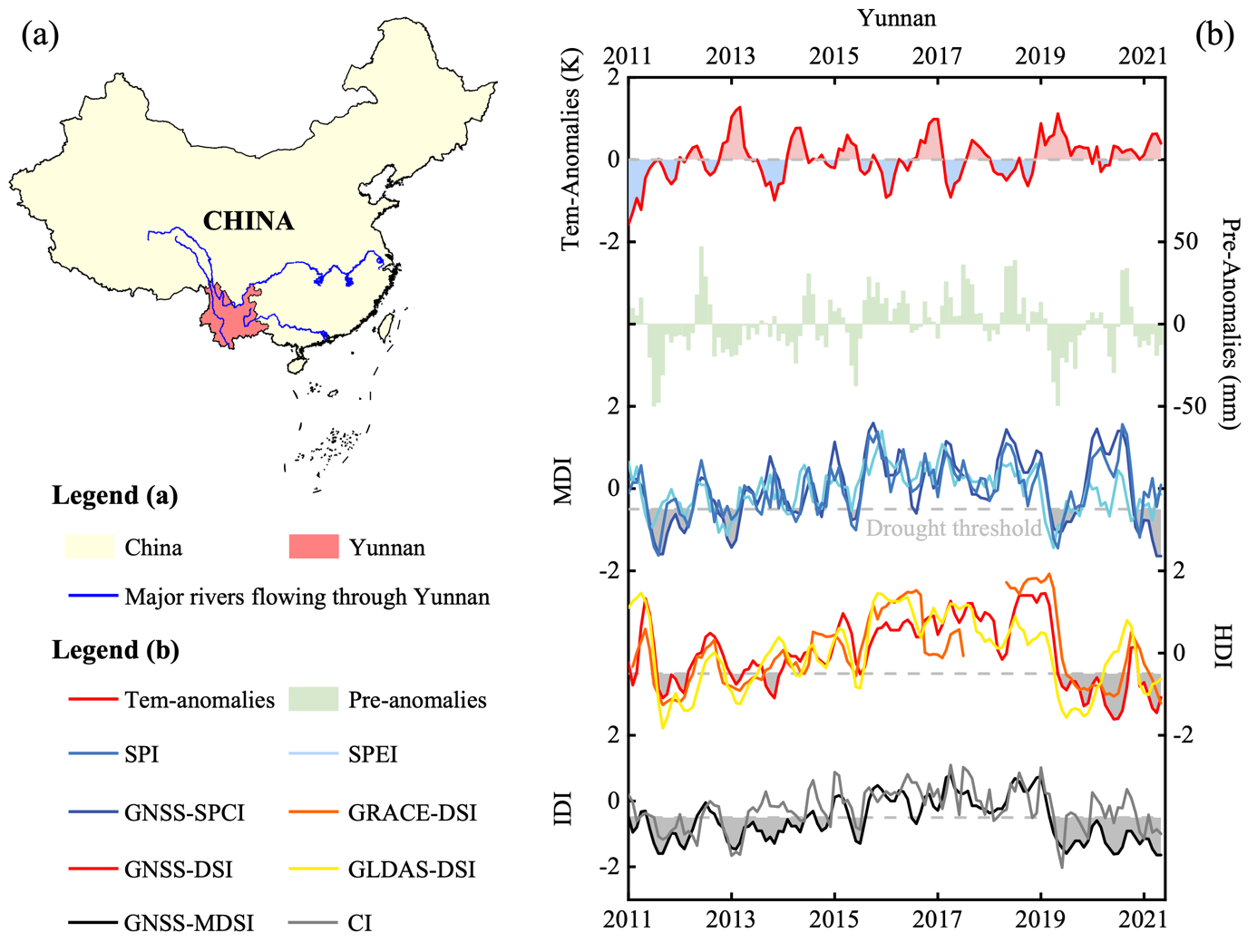
Figure 3. The geographical locations of Yunnan, China (a), and the comparison of the meteorological drought index (GNSS-SPCI/SPI/SPEI), hydrological drought index (GNSS-DSI/GRACE-DSI/GLDAS-DSI), and integrated drought index (GNSS-MDSI/CI) (b).
The GNSS-based integrated drought characterization framework not only considers precipitation efficiency related to meteorological conditions, but also accounts for terrestrial water storage reflecting hydrological dynamics. This makes it advantageous for characterizing and monitoring droughts. Given the increasing global density of GNSS stations, this framework suggests that, in addition to their existing applications in positioning, navigation, timing, and crustal movement monitoring, GNSS can also provide new approaches for integrated drought characterization and analysis in the context of global climate change.
Ph.D. student Hai Zhu is the first author, and Associate Professor Kejie Chen is the corresponding author. Key collaborators include Chair Professor Junguo Liu from SUSTech and Assistant Researcher Shunqiang Hu from Jiangxi Normal University.
The research was supported by the Guangdong Natural Science Fund 2023 – General Program and the Guangdong Provincial Key Laboratory of Geophysical High-resolution Imaging Technology.
Paper link: https://doi.org/10.1016/j.rse.2024.114261
To read all stories about SUSTech science, subscribe to the monthly SUSTech Newsletter.
Proofread ByAdrian Cremin, Yingying XIA
Photo ByDepartment of Earth and Space Sciences