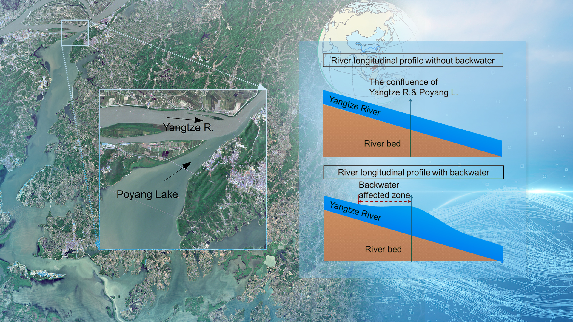
Interconnected river-lake systems are much more complex than individual rivers or lakes due to their interactions. The Poyang Lake-Yangtze River system is such a system that has received much attention due to the reverse flow from the Yangtze River, blocking the flow of Poyang Lake and causing extensive inundation.
Previous studies primarily focused on the impacts of the Yangtze River on Poyang Lake. A less explored perspective is the backwater effects of Poyang Lake on the Yangtze River. Broadly, the backwater effects may occur when one or more downstream elements, such as lakes, tributaries, ponds, dams, levees, and tides, exist. Consequently, the river flow will be blocked, and water will be backed up by the downstream elements such that the water level is higher than the smallest level required for conveying the same discharge.
Assistant Professor Liguang Jiang’s research team from the School of Environmental Science and Engineering (ESE) at the Southern University of Science and Technology (SUSTech) has recently published a paper that investigates the Poyang Lake-Yangtze River interaction from the perspective of the backwater effect on the Yangtze River. In this study, they aimed to answer four questions: Is the backwater effect of Poyang Lake negligible or pronounced? If nonnegligible, to what extent does the backwater affect the Yangtze River? How does the interplay of Poyang Lake outflow and Yangtze River discharge affect the backwater events? How much is the river water level elevated due to the backwater effects?
Their research work, entitled “A New Understanding of the Poyang Lake-Yangtze River Interaction: A Backwater Effect on the Yangtze River Perspective”, has been published in Geophysical Research Letters, a top journal in the field of geophysical research.
To answer these questions, they applied basic hydraulic principles and models to study river water surface slope (WSS) dynamics of several reaches close to the Poyang Lake-Yangtze River confluence (Figure 1).
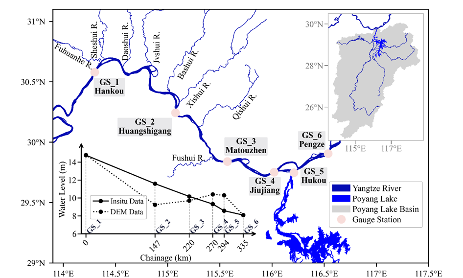
Figure 1. A detailed river network of the Yangtze River between Hankou station and Pengze station, along with the six gauging stations.
The results show that the backwater effects of Poyang Lake exerted on the Yangtze River are pronounced, leading to elevated water levels and associated declined WSS (Figure 2). It is evident that the WSS for most reaches less variable throughout the year, while WSS_4-5 is remarkably higher during the dry seasons than wet seasons. Notably, near the river-lake confluence, WSS_4-5 and WSS_5-6 have very distinct temporal patterns. Specifically, WSS_4-5 begins to decline quickly in mid-February, reaching three local minimums at the end of March, June, and September, respectively, and peaking in late December. In contrast, WSS_5-6 generally follows the opposite direction, quickly rising at the end of March, reaching a maximum in June and July, and resuming the lower value in late December. Moreover, WSS_5-6 even exceeded WSS_4-5 from June to July.
Such a phenomenon is mainly driven by backwater effects. In a normal state, a river reach’s WSS does not change dramatically, especially not across a long period of 12 months in a multi-year average condition. The observed variability thus points to the influence of backwater from Poyang Lake.
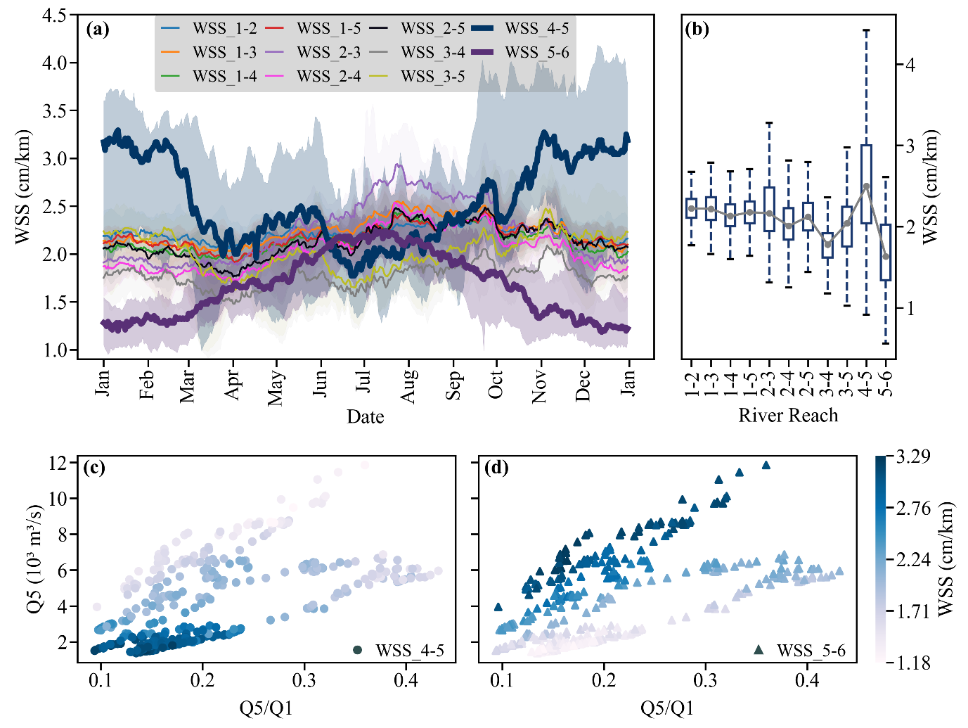
Figure 2. Intra-annual variation of WSS at the multi-year (2007-2020) level for the total of 11 river reaches from Hankou to Pengze.
The researchers used a semi-quantitative approach to determine the extent to which backwater affects the Yangtze River. Due to longer distances, the upstream stations are less affected by backwater effects (Figure 3). Thus, the water slope variations are smaller. For example, in Figure 3a, although the reach is affected by backwater, the correlation between WSS and Q5/Q1 is moderate (r= -0.53). This can be explained by the unequal impacts of backwater exerted on GS_4 and GS_5, which leads to different rises in water levels at the gauges. The data suggests that backwater extends further upstream beyond gauge 4 (Figure 3b).
Both WSS_3-5 and WSS_3-4 decline as the flow ratio increases. One may attribute this to upstream flooding, such an explanation is not possible in multi-year conditions. Moreover, the difference (∆WSS_35-34) between WSS_3-5 and WSS_3-4 also declines rather than remaining constant, which again rules out typical flooding behavior. The reason for this varying ∆WSS_35-34 is that the water level rising rate is also changing and is larger at GS_5 than at GS_4. In January and February, RR_3-5 is steeper than RR_3-4 (Figure 3b). As the flow ratio increases, RR_3-5 is getting less steep, and in June, it is almost the same as RR_3-4, indicating that the backwater is stronger at GS_5 than GS_4. Nevertheless, this analysis suggests that the backwater can extend up to GS_4, although not that strong compared to GS_5.
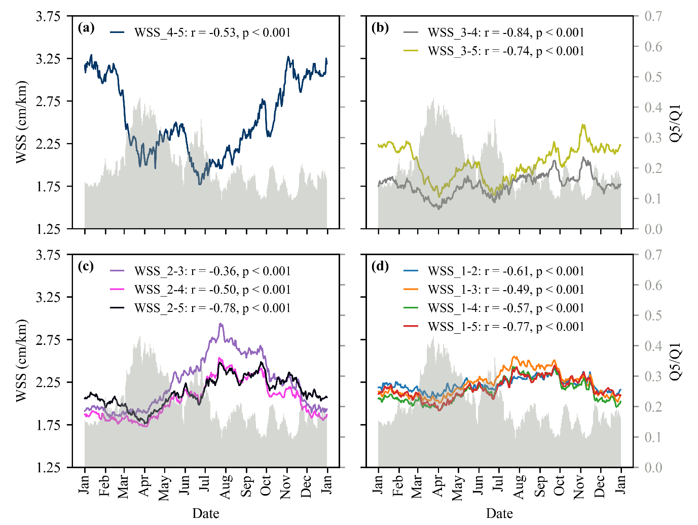
Figure 3. Temporal variations of WSS and the ratio of discharge for ten reaches under multi-year average conditions (2007-2020).
To further explore the potential effects of upstream flow and downstream backwater, the researchers analyzed the correlation between flows from the upstream Yangtze River and Poyang Lake and WSS (Figure 4). In general, the closer to GS_1 (Q1), the stronger the correlation between Q1 and WSS, indicating larger flow increases the WSS. One exception is WSS_1-2, which shows a weaker correlation with Q1. This can be attributed to the influences of six major tributaries between GS_1 and GS_2 (Figure 1). However, there are no significant lateral inflows entering the Yangtze River downstream of GS_2. All reaches starting from GS_2 are strongly correlated with Q1, showing the dominant control of upstream flow at GS_2. Moreover, WSS_3-5 and WSS_4-5 show strong negative correlations with Q1, indicating that backwater is the dominant factor influencing WSS at these two reaches. This aligns with earlier observations.
Figure 4b shows the effect of Poyang Lake flow (Q5) on WSS. There are no statistical correlations between WSS_1-2 and Q5, and the correlations between WSS_1-3, WSS1-4, and Q5 are weak, indicating no backwater effect at GS_1. This is also in line with Figure 3d. The correlations between WSS_2-3, WSS2-4, and Q5 are positive but weaker than with Q1, suggesting a dominant control of upstream flow. In contrast, both WSS_3-5 and WSS_4-5 have strong negative correlations with Q5, suggesting the backwater effect. While WSS_3-4 negatively correlates with Q5, it weakly correlates with Q1, indicating that RR_3-4 is still dominated by downstream backwater.
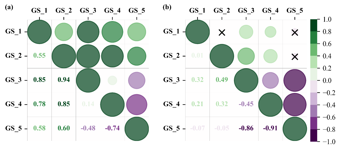
Figure 4. The correlation matrix of median WSS with median Q values under the multi-year (2007-2020) condition.
To investigate the magnitude of the elevated water level, the team studied one section at GS_4 due to the lack of detailed bathymetry of the whole reach. They calculated the elevated water levels (ydiff) using different values of Manning’s n (Figure 5). The results demonstrate that Manning’s n has a large impact on the elevated water levels. Nevertheless, the elevated water level increases with the decrease of WSS in all scenarios (Figure 5). A stronger backwater (higher ydiff) generally leads to a very flat slope, i.e., 0.9-1.4 cm/km.
The maximum ydiff values for different combinations range from 2.6 to 14.1 meters (Figure 5). This means that in the worst case, ydiff can be up to 14.1 meters (Figure 5a), while in the best case, the max ydiff is still up to 2.6 meters (Figure 5r). In the most reasonable case, i.e., Manning’s n taking the value between 0.015 and 0.055, the highest elevated water level is about 7.1m (Figure 5h).
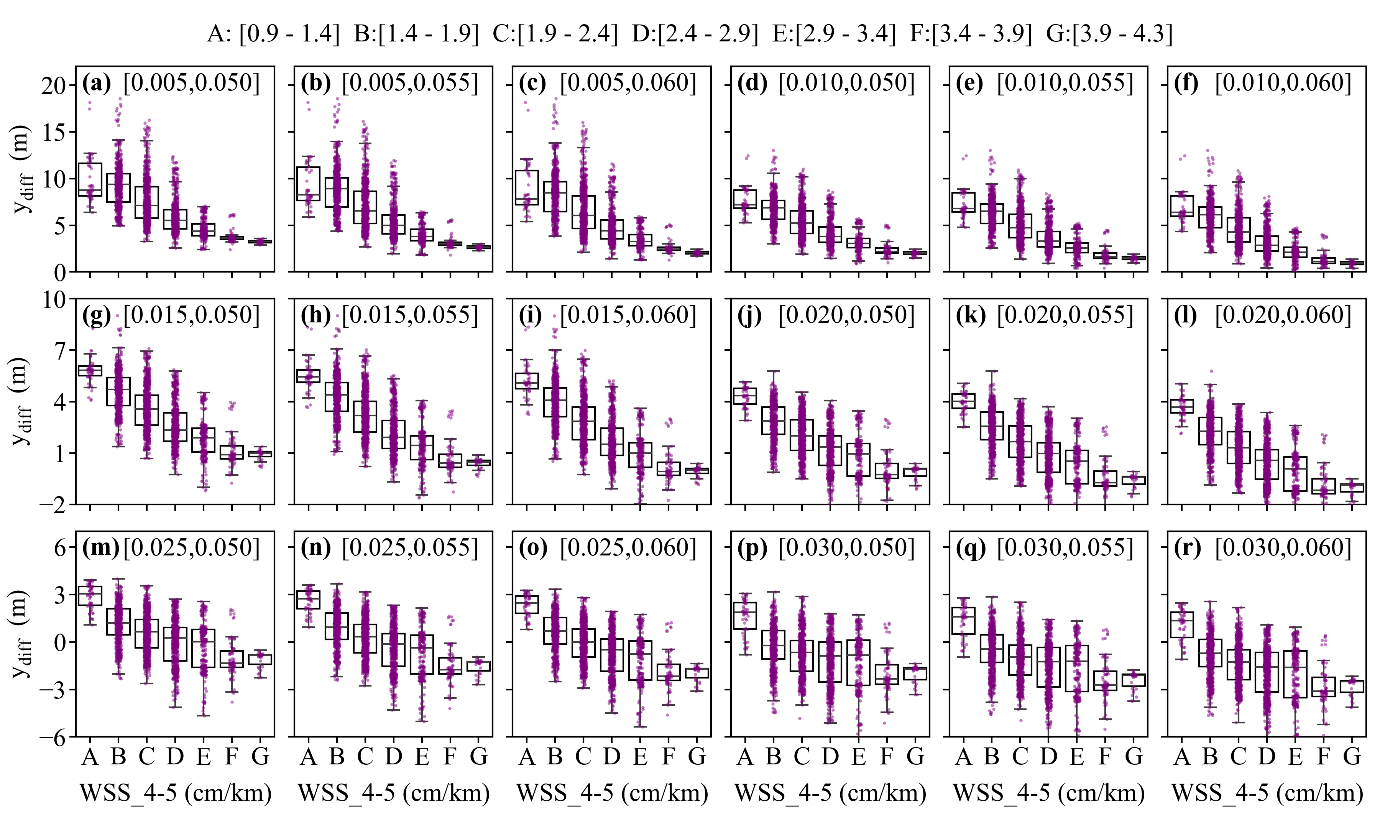
Figure 5. Estimates of raised water level, i.e., ydiff, grouped into different WSS intervals under 18 sets of minimum and maximum Manning’s n values.
The findings shown in this study are essential for flood control, flood risk evaluation, and engineering issues. In a warming climate, extreme flood events will likely become more frequent, which will likely induce stronger backwater at the confluence of Poyang Lake and the Yangtze River. Therefore, the backwater affected reach will likely be more upstream, and the associated water levels will also be much higher. Such situations will increase flood risks and challenge the current flood-prevention infrastructure of the Yangtze River. Therefore, continuous monitoring of river WSS is necessary. This work also proposes, in the future, using satellite data, such as SWOT, to continuously monitor river-long profile dynamics from space.
Master’s student Yuanyuan Meng in Assistant Professor Liguang Jiang’s research group is the first author of the paper. Assistant Professor Jiang is the corresponding author, and SUSTech is the first affiliation.
Paper link: https://agupubs.onlinelibrary.wiley.com/doi/10.1029/2025GL114807
To read all stories about SUSTech science, subscribe to the monthly SUSTech Newsletter.
Proofread ByAdrian Cremin, Yilin ZHOU
Photo BySchool of Environmental Science and Engineering


