Research Assistant Professor Wei Qi’s team from the School of Environmental Science and Engineering at the Southern University of Science and Technology (SUSTech) has recently achieved a series of important results on extreme hydrological events and extreme climate influence on hydrological processes. He has successively published four academic papers in renowned journals such as Geophysical Research Letters, Environmental Research Letters, Journal of Geophysical Research: Atmospheres, and Journal of Hydrology.

The first study, entitled “Increasing concurrent drought probability in global main crop production countries,” was published in Geophysical Research Letters. Understanding concurrent drought events in global main croplands are crucially important for food security, effective adaptation to climate change, and human well-being. Yet, there is a lack of comprehensive studies on concurrent drought probability changes among main crop production countries on a global scale, especially for the future.
In this research, they studied the concurrent drought among 26 main crop production countries for the time period 1861–2099. During the historical period, the results showed that the probability of concurrent moderate and severe drought among the countries was relatively low, and the maximum concurrent moderate and severe drought probability would double and triple under extreme climate scenarios, respectively. Concurrent probability of moderate and severe drought between China and the United States of America, Brazil, and Russia will be at least 6% and 5% under the business-as-usual scenarios, respectively, compared with zero in the historical period. Limiting RCPs to RCP2.6 can decrease the concurrent probability of severe drought by at least 2% (at least 3% for RCP8.5). This research could inform the countries’ food policies and possible global impact mitigation strategies.
Figure 1. Concurrent drought probability between countries studied
The second study, entitled “Economic growth dominates rising potential flood risk in the Yangtze River and benefits of raising dikes from 1991 to 2015,” was published in Environmental Research Letters. Flooding in the Yangtze River Basin could severely damage socio-economic development, river ecosystems, food security, hydropower production, and transportation in China. The Yangtze River Basin accounts for approximately 30% of China’s gross domestic product (GDP) and is an engine for the country’s rapid economic growth. One commonly held belief is that climate change has intensified extreme flood events, leading to increasing economic damage in the Yangtze River.
In this research, Prof. Qi’s team coupled the WEB-DHM-S hydrological model and the CaMa-Flood hydraulic model to generate the WEB-DHM-SG model, which is suitable for large-scale/global hydrological simulation. Then, they applied the WEB-DHM-SG to the Yangtze River in China. They found that climate-induced changes in flood inundation areas and resulting economic exposure decreased overall. In contrast, GDP growth increased potential economic exposure to floods. Based on this model, they also evaluated the benefits of raising dikes in the Yangtze River. The study has significant policy and socio-economic development implications.

Figure 2. Flooding risk in the middle and lower reaches of the Yangtze River
Their third study, entitled “Divergent and changing importance of glaciers and snow as natural water reservoirs in the eastern and southern Tibetan Plateau,” was published in the Journal of Geophysical Research: Atmospheres. Glaciers and snow are natural water reservoirs in the Tibetan Plateau (TP), affecting ecosystems, water and food security, and more than one billion downstream people. Meltwater volumes are traditionally estimated using the degree-day concept considering only air temperature, which cannot consider the influence of downward solar and longwave radiation, humidity, wind, and resultant turbulent heat fluxes.
In this work, the researchers used a physically based energy budget approach considering the full energy balance in seven large river basins in the eastern and southern Tibetan Plateau. From 1982-2011, they estimated that the average glacier melt was 0.32 m water equivalent/year with large spatial variability, and the glacier melts accelerated at a rate of 0.42 mm/year. On average, snow and glacier melt contributed 17.6% of annual river discharge during 1982-2011, including 10.0% from snow and 7.6% from glaciers. Mainly due to decreasing snowmelt, glacier and snowmelt contributions to discharge would decrease to 11.9% during 2021-2050 under the extreme climate scenario. This study provides critical information on the importance of glaciers and snow as natural water reservoirs to sustain freshwater supplies for people and ecosystems.
Figure 3. Snow and glacier melt contribution to discharge in the eastern and southern Tibetan Plateau
The fourth study, entitled “Warming winter, drying spring and shifting hydrological regimes in Northeast China under climate change,” was published in the Journal of Hydrology. As an important agriculture production area globally and a flood-prone area, future hydro-climate changes in winter and spring in Northeast China could have a remarkable influence on spring water resources and floods. Yet, studies on future hydro-climate variations with special considerations of snow influences remain limited in the region.
In this research, Prof. Qi’s team studied the snow changes and the hydrological impacts in Northeast China under climate change. The results showed that winter is warming faster than spring. Compared to the historical period, snowmelt contribution to spring average and maximum runoff would decrease by at least 39% and 23%, respectively, during the near future 2030-2059 time period. Under the extreme climate, the peak time of spring snowmelt runoff would move from April to March, and snowmelt contribution to runoff would decrease to almost zero in May at the end of this century. This study is useful for adaption to climate change and developing sustainable water management strategies for Northeast China.
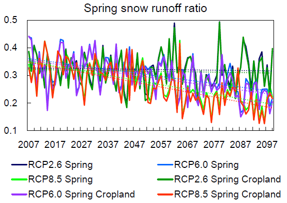
Figure 4. Spring snow runoff ratio under climate change
Prof. Wei Qi is the first author of all the above papers. Prof. Lian Feng is the corresponding author, and SUSTech is the first unit of the papers.
These studies were funded by the Strategic Priority Research Program of the Chinese Academy of Sciences and the National Natural Science Foundation of China (NSFC).
Paper links (In order of appearance above):
Geophysical Research Letters: https://doi.org/10.1029/2021GL097060
Environmental Research Letters: https://doi.org/10.1088/1748-9326/ac5561
Journal of Geophysical Research: Atmospheres: https://doi.org/10.1029/2021JD035888
Journal of Hydrology: https://doi.org/10.1016/j.jhydrol.2021.127390
To read all stories about SUSTech science, subscribe to the monthly SUSTech Newsletter.
Proofread ByAdrian Cremin, Yingying XIA
Photo By